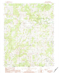
1984 Map of Myrtle
USGS Topo · Published 1984About this map
Myrtle serves as a focal point in this southern Oregon County landscape, where the Missouri-Arkansas border cuts across the southern edge near Farewell. The area is defined by its deep hollows and spring-fed waters, including Gum Spring and Hesley Spring, which feed into an intricate drainage system featuring Frederick Creek and Spring Valley Creek. Local community life in the mid-1980s is anchored by a high density of rural churches and educational sites, such as Couch Schools, New Salem Ch, and Community Ch.
Find a feature on this map
52 named features on this map. Tap any name to fly to it.
Don’t see what you’re looking for? This feature index may not catch every label — zoom into the map to look around manually.
Map Details
Editions of this 1984 Myrtle Map
This is the sole edition of this map. No revisions or reprints were ever made.
Other maps of this area

1941 · Gatewood
USGS Topo · 1:62,500

1944 · Couch
USGS Topo · 1:62,500

1945 · Gatewood
USGS Topo · 1:62,500

1946 · Couch
USGS Topo · 1:62,500

1957 · Poplar Bluff
USGS Topo · 1:250,000

1959 · Poplar Bluff
USGS Topo · 1:250,000

1960 · Poplar Bluff
USGS Topo · 1:250,000
1965 · Riverton
USGS Topo · 1:24,000
1966 · Billmore
USGS Topo · 1:24,000
1968 · Hardy NE
USGS Topo · 1:24,000