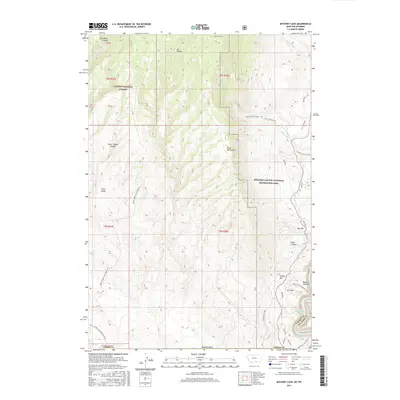
2017 Map of Mystery Cave
USGS Topo · Published 2017About this map
Mystery Cave sits high in the Pryor Mountains, a landscape defined by dramatic elevation changes and deep drainages along the Montana and Wyoming border. This area within the Custer National Forest and the Bighorn Canyon National Recreation Area is marked by a complex network of ridgelines and canyons, including Lost Water Canyon and Burnt Timber Canyon. The southern portion of the map reveals the transition toward the Bighorn River and the waters of Bighorn Lake, which cuts through the massive walls of Bighorn Canyon. Historic travel through this difficult terrain is evidenced by Bad Pass and early roads like the Burnt Timber-Tillet Ridge Rd, which trace the high ground of Tillet Ridge. The geography here transitions from the limestone uplands down to the Crooked Creek Plateau, where the Stateline marks the boundary between Carbon County and Big Horn County.
Find a feature on this map
43 named features on this map. Tap any name to fly to it.
Don’t see what you’re looking for? This feature index may not catch every label — zoom into the map to look around manually.
Map Details
Editions of this 2017 Mystery Cave Map
This is the sole edition of this map. No revisions or reprints were ever made.
Other maps of this area

1954 · Billings
USGS Topo · 1:250,000

1955 · Cody
USGS Topo · 1:250,000

1957 · Billings
USGS Topo · 1:250,000

1958 · Billings
USGS Topo · 1:250,000

1958 · Cody
USGS Topo · 1:250,000

1962 · Cody
USGS Topo · 1:250,000

1964 · Big Ice Cave
USGS Topo · 1:24,000

1964 · Red Pryor Mountain
USGS Topo · 1:24,000
1964 · Dead Indian Hill
USGS Topo · 1:24,000

1964 · Sykes Spring
USGS Topo · 1:24,000