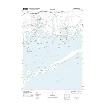
2011 Map of Mystic
USGS Topo · Published 2011About this map
Mystic Seaport anchors this coastal landscape, illustrating the deep maritime history of the Connecticut shoreline. The complex shoreline includes the village of Mystic, where the Mystic Bascule Bridge crosses the Mystic River, and the established settlements of Stonington, Noank, and West Mystic. The map reveals a high density of small family and community cemeteries, such as Gallup Cemetery, Packer Cemetery, and the Old Breakwater Cemetery, which serve as vital markers for local genealogical research. Nautical safety and commerce are central to the area's identity, evidenced by landmarks like the Old Stone Lighthouse and the Stonington Harbor Lighthouse. Further south across the Fishers Island Sound, the northern fringe of Fishers Island is visible, featuring various inland water bodies like Treasure Pond and Middle-Farms Pond along its rocky, indented coast.
Find a feature on this map
165 named features on this map. Tap any name to fly to it.
Don’t see what you’re looking for? This feature index may not catch every label — zoom into the map to look around manually.
Map Details
Editions of this 2011 Mystic Map
This is the sole edition of this map. No revisions or reprints were ever made.
Other maps of this area

1889 · Stonington
USGS Topo · 1:62,500

1892 · New London
USGS Topo · 1:62,500

1893 · Stonington
USGS Topo · 1:62,500

1893 · New London
USGS Topo · 1:62,500

1903 · Gardiners Island
USGS Topo · 1:62,500

1904 · Gardiners Island
USGS Topo · 1:62,500

1904 · Montauk
USGS Topo · 1:62,500

1921 · Gardiners Island
USGS Topo · 1:62,500

1921 · New London
USGS Topo · 1:62,500

1921 · Stonington
USGS Topo · 1:62,500