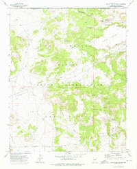
1973 Map of Na Ah Tee Canyon
USGS Topo · Published 1976About this map
Na Ah Tee Trading Post stands as a focal point in this 1970s survey of the Navajo Indian Reservation, situated near the junction of canyon and mesa terrain. The landscape is defined by the Hopi Buttes and the expansive Gray Mesa, with a notable concentration of water sources such as Na Ah Tee Canyon Spring and Doh-Halian Spring that were vital for local subsistence.
Find a feature on this map
28 named features on this map. Tap any name to fly to it.
Don’t see what you’re looking for? This feature index may not catch every label — zoom into the map to look around manually.
Map Details
Editions of this 1973 Na Ah Tee Canyon Map
This is the sole edition of this map. No revisions or reprints were ever made.
Other maps of this area

1883 · Tusayan
USGS Topo · 1:250,000

1886 · Tusayan
USGS Topo · 1:250,000

1947 · Flagstaff
USGS Topo · 1:250,000

1954 · Flagstaff
USGS Topo · 1:250,000

1958 · Flagstaff
USGS Topo · 1:250,000

1960 · Flagstaff
USGS Topo · 1:250,000

1962 · Flagstaff
USGS Topo · 1:250,000

1966 · White Cone
USGS Topo · 1:62,500

1966 · Egloffstein Butte
USGS Topo · 1:62,500
1967 · Dilkon
USGS Topo · 1:24,000