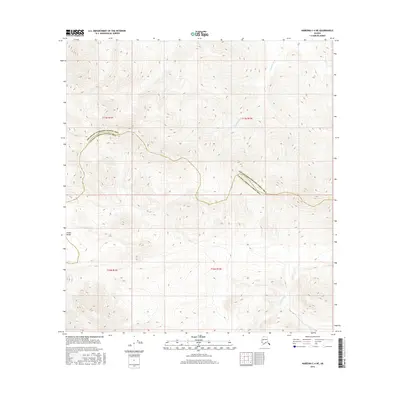
2016 Map of Nabesna C-4 NE
USGS Topo · Published 2016About this map
The Alaska Range dominates this terrain within the Unorganized Borough, where the high-altitude landscape is defined by the sharp transition between the Southeast Fairbanks Census Area and the Valdez-Cordova Census Area. This 2016 survey illustrates a largely roadless interior wilderness, shaped by glacial drainage systems. The Kalukna River flows through the northern reaches of the quadrangle, while the Chesna River marks the southeastern quadrant. The complex topography shown here emphasizes the drainage patterns of these rivers as they navigate the steep elevation drops characteristic of this part of the state. With no established settlements or infrastructure printed on the sheet, the focus remains entirely on the natural hydrology and the administrative boundary line that traverses the center of the range.
Find a feature on this map
8 named features on this map. Tap any name to fly to it.
Don’t see what you’re looking for? This feature index may not catch every label — zoom into the map to look around manually.
Map Details
Editions of this 2016 Nabesna C-4 NE Map
This is the sole edition of this map. No revisions or reprints were ever made.
Other maps of this area

1950 · Nabesna
USGS Topo · 1:250,000

1951 · Nabesna
USGS Topo · 1:250,000

1954 · Nabesna D-3
USGS Topo · 1:63,360

1954 · Nabesna C-3
USGS Topo · 1:63,360

1954 · Nabesna D-4
USGS Topo · 1:63,360

1955 · Nabesna D-3
USGS Topo · 1:63,360

1955 · Nabesna C-3
USGS Topo · 1:63,360
1960 · Nabesna D-4
USGS Topo · 1:63,360

1960 · Nabesna
USGS Topo · 1:250,000

1960 · Nabesna C-4
USGS Topo · 1:63,360