
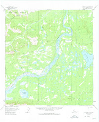
1955 Map of Nabesna C-3
USGS Topo · Published 1958About this map
Tetlin Indian Reservation occupies the northwest portion of this landscape, its boundary cutting through a complex network of wetlands and upland terrain in the mid-1950s. The wide, braided channels of the Nabesna River dominate the central valley, shifting through gravel bars and silty lowlands. To the east, the large expanse of Jatahmund Lake sits as a primary landmark among dozens of smaller, unnamed water bodies. Transportation through this roadless interior is limited to a single Tractor Trail that meanders across the northern hills. The map illustrates a transitional subarctic environment where the drainage of Lick Creek and the Pickerel Lakes reflect the intricate hydrology of the Fourth Judicial Division before modern development.
Find a feature on this map
7 named features on this map. Tap any name to fly to it.
Don’t see what you’re looking for? This feature index may not catch every label — zoom into the map to look around manually.
Map Details
Editions of this 1955 Nabesna C-3 Map
2 editions found
Other maps of this area

1950 · Nabesna
USGS Topo · 1:250,000

1951 · Nabesna
USGS Topo · 1:250,000

1954 · Nabesna D-2
USGS Topo · 1:63,360

1954 · Nabesna D-3
USGS Topo · 1:63,360

1954 · Nabesna C-3
USGS Topo · 1:63,360

1954 · Nabesna D-4
USGS Topo · 1:63,360

1955 · Nabesna C-2
USGS Topo · 1:63,360

1955 · Nabesna D-3
USGS Topo · 1:63,360

1955 · Nabesna D-2
USGS Topo · 1:63,360

1960 · Nabesna B-4
USGS Topo · 1:63,360