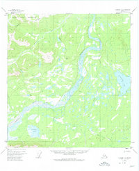
1955 Map of Nabesna C-3
USGS Topo · Published 1975About this map
The Nabesna River winds through this subarctic terrain, creating a complex braided channel system that dominates the central valley. To the northwest, the Tetlin Indian Reservation occupies a significant portion of the landscape, defined by a boundary line that cuts across the Cheslina River. The area is characterized by low-lying wetlands and scattered water bodies, including the sizable Jatahmund Lake and the smaller Pickerel Lakes. Settlement is sparse, represented only by isolated Cabins and a Cabin located near the riverbanks and lake shores.
Find a feature on this map
14 named features on this map. Tap any name to fly to it.
Don’t see what you’re looking for? This feature index may not catch every label — zoom into the map to look around manually.
Map Details
Editions of this 1955 Nabesna C-3 Map
2 editions found
Other maps of this area

1950 · Nabesna
USGS Topo · 1:250,000

1951 · Nabesna
USGS Topo · 1:250,000

1954 · Nabesna D-2
USGS Topo · 1:63,360

1954 · Nabesna D-3
USGS Topo · 1:63,360

1954 · Nabesna C-3
USGS Topo · 1:63,360

1954 · Nabesna D-4
USGS Topo · 1:63,360

1955 · Nabesna C-2
USGS Topo · 1:63,360

1955 · Nabesna D-3
USGS Topo · 1:63,360

1955 · Nabesna C-3
USGS Topo · 1:63,360

1955 · Nabesna D-2
USGS Topo · 1:63,360