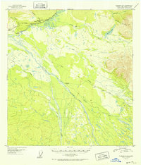
1952 Map of Nabesna C-6
USGS Topo · Published 1952About this map
Copper River and its braided drainage systems dominate this interior Alaskan landscape as it was documented in the late 1940s. The settlement of Slana serves as a focal point where the Glenn Highway meets the historic Eagle Trail, illustrating the evolution of transport from pioneer footpaths to modern road networks. Further east, the Alaska Road Commission Camp highlights the mid-century infrastructure push in the territory. The map reveals a transition from the high peaks of the Mentasta Mountains near Suslota Lake down to the river valleys where Batzulnetas and various cabins are situated. This survey captures a moment when the Nabesna Road was a primary artery for reaching the remote interior, while the landscape remained largely defined by traditional water routes like Tanada Creek and Suslota Creek.
Find a feature on this map
20 named features on this map. Tap any name to fly to it.
Don’t see what you’re looking for? This feature index may not catch every label — zoom into the map to look around manually.
Map Details
Editions of this 1952 Nabesna C-6 Map
2 editions found
Other maps of this area

1948 · Nabesna C-6
USGS Topo · 1:63,360

1948 · Nabesna D-5
USGS Topo · 1:63,360

1949 · Nabesna D-6
USGS Topo · 1:63,360

1949 · Gulkana C-1
USGS Topo · 1:63,360

1950 · Nabesna
USGS Topo · 1:250,000

1950 · Nabesna D-5
USGS Topo · 1:63,360

1951 · Gulkana
USGS Topo · 1:250,000

1951 · Nabesna
USGS Topo · 1:250,000

1952 · Nabesna C-6
USGS Topo · 1:63,360

1952 · Nabesna D-5
USGS Topo · 1:63,360