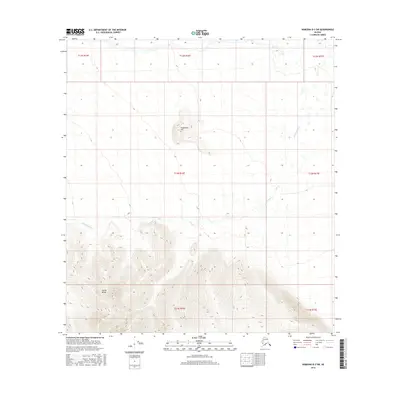
2016 Map of Nabesna D-3 SW
USGS Topo · Published 2016About this map
Alaska Range peaks dominate the southern portion of this region, providing a stark topographical contrast to the river valley to the north. The landscape is defined by the winding path of the Kalukna River, which meanders across the central and northern sections of the terrain. Near the center of the map, Taixtsalda Hill rises as a prominent landmark, standing distinct from the higher elevations of the mountains to the south. This area, documented by the U.S. Geological Survey with data from the Bureau of Land Management and the U.S. Fish and Wildlife Service, remains largely undeveloped, preserving the original hydrography and elevation patterns of this part of the Alaskan interior.
Find a feature on this map
10 named features on this map. Tap any name to fly to it.
Don’t see what you’re looking for? This feature index may not catch every label — zoom into the map to look around manually.
Map Details
Editions of this 2016 Nabesna D-3 SW Map
This is the sole edition of this map. No revisions or reprints were ever made.
Other maps of this area

1950 · Nabesna
USGS Topo · 1:250,000

1951 · Nabesna
USGS Topo · 1:250,000

1954 · Nabesna D-3
USGS Topo · 1:63,360

1954 · Nabesna C-3
USGS Topo · 1:63,360

1954 · Nabesna D-4
USGS Topo · 1:63,360

1955 · Nabesna D-3
USGS Topo · 1:63,360

1955 · Nabesna C-3
USGS Topo · 1:63,360
1960 · Nabesna D-4
USGS Topo · 1:63,360

1960 · Nabesna
USGS Topo · 1:250,000

1960 · Nabesna C-4
USGS Topo · 1:63,360