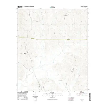
2014 Map of Nadawah
USGS Topo · Published 2014About this map
The Wilcox Co Monroe Co boundary line divides this rural landscape, where the settlements of Nadawah, Watsonville, and Chestnut represent the primary residential hubs. The terrain is defined by a dense network of meandering watercourses, most notably Big Flat Cr and Flat Cr, which drain through the timbered hills. For genealogists and local historians, the map identifies several significant burial sites, including Saint Matthews Cem near Chestnut and both Pineview Cem and Turkestan Cem in the southeastern portion of the quadrangle. A system of county and local roads, such as Pineville Rd and Nadawah Rd, connects these small communities and provides access to the creek bottoms. The geography suggests a continuation of traditional land use patterns, centered on the natural drainage of Galley Cr and Dailey Cr.
Find a feature on this map
29 named features on this map. Tap any name to fly to it.
Don’t see what you’re looking for? This feature index may not catch every label — zoom into the map to look around manually.
Map Details
Editions of this 2014 Nadawah Map
This is the sole edition of this map. No revisions or reprints were ever made.
Other maps of this area

1953 · Andalusia
USGS Topo · 1:250,000

1957 · Andalusia
USGS Topo · 1:250,000

1967 · Beatrice
USGS Topo · 1:24,000

1971 · Skinnerton
USGS Topo · 1:24,000

1971 · Beatrice
USGS Topo · 1:24,000

1972 · Natchez
USGS Topo · 1:24,000

1973 · Camden South
USGS Topo · 1:24,000

1973 · Vredenburgh
USGS Topo · 1:24,000
1981 · Rosebud
USGS Topo · 1:24,000
1981 · Oak Hill
USGS Topo · 1:24,000