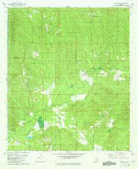
1981 Map of Nadawah
USGS Topo · Published 1981About this map
The Louisville and Nashville railroad corridor defines the development of this southern Alabama landscape, cutting a diagonal path through the timberlands and creek bottoms of the Wilcox Co Monroe Co line. Established around the turn of the 20th century as a lumbering center, Nadawah remains the primary hub of activity, surrounded by small community centers like Chestnut and Watsons Crossing. The map reveals a deeply rooted rural social structure, evidenced by the high concentration of country churches such as Olivers Chapel, St Francis Ch, and Mt Sinai Ch. Much of the terrain is shaped by the winding course of Big Flat Creek, which creates a network of wetlands and seasonal drainages including the area known as Corduroy. This survey preserves the late-20th-century footprint of these small settlements and their associated family cemeteries before further consolidation of the local timber economy changed the landscape's character.
Find a feature on this map
13 named features on this map. Tap any name to fly to it.
Don’t see what you’re looking for? This feature index may not catch every label — zoom into the map to look around manually.
Map Details
Editions of this 1981 Nadawah Map
This is the sole edition of this map. No revisions or reprints were ever made.
Other maps of this area

1953 · Andalusia
USGS Topo · 1:250,000

1957 · Andalusia
USGS Topo · 1:250,000

1967 · Beatrice
USGS Topo · 1:24,000

1971 · Skinnerton
USGS Topo · 1:24,000

1971 · Beatrice
USGS Topo · 1:24,000

1972 · Natchez
USGS Topo · 1:24,000

1973 · Camden South
USGS Topo · 1:24,000

1973 · Vredenburgh
USGS Topo · 1:24,000
1981 · Rosebud
USGS Topo · 1:24,000
1981 · Oak Hill
USGS Topo · 1:24,000