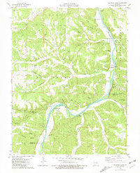
1980 Map of Nagogami Lodge
USGS Topo · Published 1981About this map
The Gasconade River carves a winding path through the Ozark highlands of southern Maries County, defining the local geography with its dramatic loops and high bluffs. During this 1980 survey, the river corridor serves as a hub for both travel and recreation, featuring the namesake Nagogami Lodge and the Bell Chute Public Access point. The landscape is characterized by a dense network of hollows, including West Hollow and Montague Hollow, while smaller communities like Hayden and Stickney maintain their presence on the higher ground. Genealogists will find a wealth of family history preserved in remote burial grounds such as Fulkerson Cem, Davis Cem, and Ramsey Cem. The transition from river bottom to ridge is further marked by features like Gaines Ford Br and the Natural Bridge near Clifty Creek, showcasing the area's complex karst topography.
Find a feature on this map
57 named features on this map. Tap any name to fly to it.
Don’t see what you’re looking for? This feature index may not catch every label — zoom into the map to look around manually.
Map Details
Editions of this 1980 Nagogami Lodge Map
This is the sole edition of this map. No revisions or reprints were ever made.
Other maps of this area

1888 · Tuscumbia
USGS Topo · 1:125,000

1894 · Tuscumbia
USGS Topo · 1:125,000

1912 · Rolla
USGS Topo · 1:62,500

1936 · Waynesville
USGS Topo · 1:48,000

1937 · Vienna
USGS Topo · 1:62,500

1938 · Vienna
USGS Topo · 1:48,000

1942 · Waynesville
USGS Topo · 1:62,500

1944 · Waynesville
USGS Topo · 1:62,500

1947 · Jefferson City
USGS Topo · 1:250,000

1948 · Tavern
USGS Topo · 1:62,500