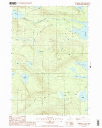
1988 Map of Nahmakanta Stream
USGS Topo · Published 1988About this map
The Appalachian National Scenic Trail winds through this Piscataquis County landscape, following the course of Nahmakanta Stream and traversing the prominent heights of Potaywadjo Ridge. This late-twentieth-century survey documents a dense network of glacial water bodies, from the sprawling reach of Nahmakanta Lake in the northwest to Pemadumcook Lake on the eastern edge. The topography is defined by significant elevations like Cooper Mountain and a complex drainage system including Deadwater Brook and Tumbledown Dick Brook. Human activity is minimal and focused on resource extraction, indicated by a Gravel Pit near the southern boundary. The map captures the remote character of these unorganized townships, including T 1 R 11 W E L S and T A R 10 W E L S, where small ponds like Henderson Pond and Church Pond remain largely isolated by the wooded terrain.
Find a feature on this map
28 named features on this map. Tap any name to fly to it.
Don’t see what you’re looking for? This feature index may not catch every label — zoom into the map to look around manually.
Map Details
Editions of this 1988 Nahmakanta Stream Map
2 editions found
Other maps of this area

1927 · Katahdin
USGS Topo · 1:48,000

1930 · Katahdin
USGS Topo · 1:62,500

1949 · Katahdin
USGS Topo · 1:62,500

1951 · Norcross
USGS Topo · 1:62,500

1952 · Jo-Mary Mountain
USGS Topo · 1:62,500

1954 · Harrington Lake
USGS Topo · 1:62,500

1954 · Millinocket
USGS Topo · 1:250,000

1958 · Millinocket
USGS Topo · 1:250,000

1960 · Millinocket
USGS Topo · 1:250,000
1978 · Rainbow Lake West
USGS Topo · 1:24,000