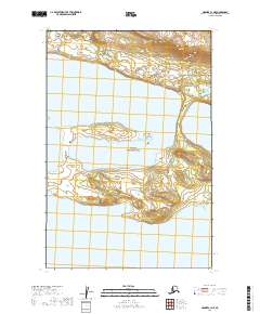
2019 Map of Naknek C-1 NE
USGS Topo · Published 2019About this map
Katmai National Park defines the central and southern expanse of this landscape, protecting a significant portion of the Alaska Peninsula. The topography is dominated by the sprawling reaches of Naknek Lake, which occupies the northern and central sections of the sheet. This 2019 survey illustrates the intricate relationship between the lake's shoreline and the surrounding protected wilderness, including various islands and peninsulas that characterize the eastern basin. As a modern topographic study, it provides a precise look at the hydrography of the region before any potential shifts in water levels or shoreline erosion, serving as a critical reference for understanding the geography of one of Alaska's most prominent national park areas.
Find a feature on this map
8 named features on this map. Tap any name to fly to it.
Don’t see what you’re looking for? This feature index may not catch every label — zoom into the map to look around manually.
Map Details
Editions of this 2019 Naknek C-1 NE Map
This is the sole edition of this map. No revisions or reprints were ever made.
Other maps of this area

1948 · Mt Katmai
USGS Topo · 1:250,000

1951 · Mt Katmai
USGS Topo · 1:250,000

1951 · Mount Katmai C-6
USGS Topo · 1:63,360

1951 · Naknek D-1
USGS Topo · 1:63,360

1951 · Naknek C-1
USGS Topo · 1:63,360

1951 · Mount Katmai D-6
USGS Topo · 1:63,360

1952 · Naknek
USGS Topo · 1:250,000

1964 · Mt. Katmai
USGS Topo · 1:250,000

1964 · Naknek
USGS Topo · 1:250,000
2019 · Mount Katmai C-6 SW
USGS Topo · 1:25,000