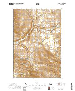
2019 Map of Naknek D-1 SE
USGS Topo · Published 2019About this map
Katmai National Park encompasses the southeastern portion of this terrain, where the landscape transitions into protected wilderness. The northern reach of the park boundary is defined by complex contour elevations that suggest significant relief rising from the valley floors. Flowing through the central and western sections, King Salmon Cr serves as the primary drainage, winding between steep ridges and high-altitude plateaus. The cartography reveals a remote environment primarily characterized by these natural hydrological and topographic features, with no modern infrastructure or permanent settlements indicated beyond the established township and range lines. The presence of these survey boundaries underscores the systematic mapping of this roadless area within the Lake and Peninsula Borough during the early twenty-first century.
Find a feature on this map
6 named features on this map. Tap any name to fly to it.
Don’t see what you’re looking for? This feature index may not catch every label — zoom into the map to look around manually.
Map Details
Editions of this 2019 Naknek D-1 SE Map
This is the sole edition of this map. No revisions or reprints were ever made.
Other maps of this area

1948 · Mt Katmai
USGS Topo · 1:250,000

1951 · Mt Katmai
USGS Topo · 1:250,000

1951 · Mount Katmai C-6
USGS Topo · 1:63,360

1951 · Naknek D-1
USGS Topo · 1:63,360

1951 · Naknek C-1
USGS Topo · 1:63,360

1951 · Mount Katmai D-6
USGS Topo · 1:63,360

1952 · Naknek
USGS Topo · 1:250,000

1964 · Mt. Katmai
USGS Topo · 1:250,000

1964 · Naknek
USGS Topo · 1:250,000
2019 · Mount Katmai D-6 SW
USGS Topo · 1:25,000