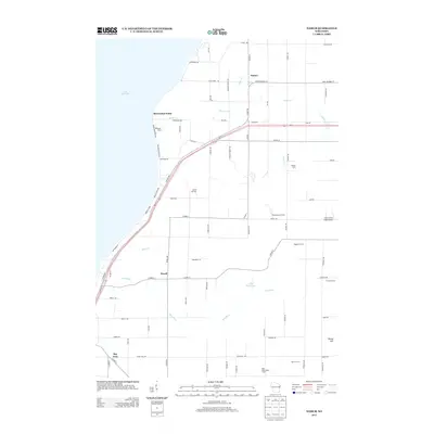
2013 Map of Namur
USGS Topo · Published 2013About this map
The agricultural uplands of Door County meet the eastern shoreline of Lake Michigan in this survey of the Southern Door area. The landscape is defined by its deep Belgian heritage, visible in the settlement patterns at Namur and Duvall. Large multi-generational farmsteads such as Baudhuin Farms, Tassout Farm, and Red River Valley Farms dominate the interior, while the shoreline is marked by prominent geography at Shoemaker Point.
Find a feature on this map
82 named features on this map. Tap any name to fly to it.
Don’t see what you’re looking for? This feature index may not catch every label — zoom into the map to look around manually.
Map Details
Editions of this 2013 Namur Map
This is the sole edition of this map. No revisions or reprints were ever made.
Other maps of this area

1952 · Casco
USGS Topo · 1:62,500

1954 · New Franken
USGS Topo · 1:62,500

1954 · Manitowoc
USGS Topo · 1:250,000

1956 · Oconto
USGS Topo · 1:62,500

1958 · Manitowoc
USGS Topo · 1:250,000

1961 · Little Sturgeon
USGS Topo · 1:62,500
1974 · Oconto SE
USGS Topo · 1:24,000

1978 · Casco
USGS Topo · 1:24,000

1978 · Namur
USGS Topo · 1:24,000
1978 · Luxemburg
USGS Topo · 1:24,000