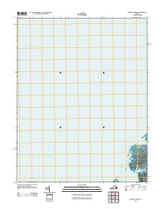
2011 Map of Nandua Creek
USGS Topo · Published 2011About this map
Chesapeake Bay dominates this coastal landscape, illustrating the intricate shoreline of Virginia's Eastern Shore. The settlement at Hacks Neck represents the primary terrestrial focus on this sheet, situated on a peninsula defined by tidal waterways. These aquatic arteries, including Nandua Creek, Butcher Creek, and Back Creek, cut into the land to create a series of points and necks typical of the region's geography. At the southern edge of the terrestrial portion, Milbys Point marks the transition between the marshy estuary and the open bay. The map reflects a modern moment in time where the traditional maritime-dependent patterns of the Eastern Shore are preserved through local road networks and the naming of these specific inlets and points.
Find a feature on this map
6 named features on this map. Tap any name to fly to it.
Don’t see what you’re looking for? This feature index may not catch every label — zoom into the map to look around manually.
Map Details
Editions of this 2011 Nandua Creek Map
This is the sole edition of this map. No revisions or reprints were ever made.
Other maps of this area

1903 · Crisfield
USGS Topo · 1:62,500

1917 · Ewell
USGS Topo · 1:62,500

1920 · Crisfield
USGS Topo · 1:62,500

1942 · Chesconessex
USGS Topo · 1:31,680

1942 · Nandua Creek
USGS Topo · 1:24,000

1942 · Tangier Island
USGS Topo · 1:24,000

1943 · Jamesville
USGS Topo · 1:31,680

1943 · Pungoteague
USGS Topo · 1:31,680
1943 · Tangier Island
USGS Topo · 1:31,680

1943 · Exmore
USGS Topo · 1:24,000