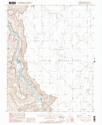
1988 Map of Nankoweap Mesa
USGS Topo · Published 1988About this map
Grand Canyon National Park and the western edge of the Navajo Indian Reservation meet along the powerful corridor of the Colorado River. This late-1980s survey captures the intersection of dramatic geological formations and ancient human history, specifically noting the presence of a Cliff Dwelling tucked within the walls of Nankoweap Canyon. The river channel is defined by significant navigational hazards like Nankoweap Rapids and Kwagunt Rapids, which have long dictated travel through the gorge. To the east, the terrain levels out across the Blue Moon Bench and Desert Facade, where the land is marked by seasonal drainages such as Tatahoysa Wash. High points like Gray Castle and the massive Nankoweap Mesa stand as prominent landmarks above the river's path through Marble Canyon.
Find a feature on this map
19 named features on this map. Tap any name to fly to it.
Don’t see what you’re looking for? This feature index may not catch every label — zoom into the map to look around manually.
Map Details
Editions of this 1988 Nankoweap Mesa Map
2 editions found
Other maps of this area

1886 · Echo Cliffs
USGS Topo · 1:250,000

1891 · Echo Cliffs
USGS Topo · 1:250,000

1907 · Vishnu
USGS Topo · 1:48,000

1954 · Nankoweap
USGS Topo · 1:62,500

1954 · Shinumo Altar
USGS Topo · 1:62,500

1955 · Blue Spring
USGS Topo · 1:62,500

1956 · Marble Canyon
USGS Topo · 1:250,000

1959 · Marble Canyon
USGS Topo · 1:250,000

1961 · Marble Canyon
USGS Topo · 1:250,000
1962 · Vishnu Temple
USGS Topo · 1:62,500