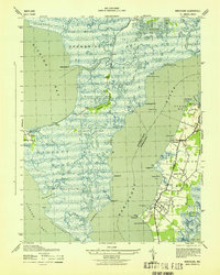
1943 Map of Nanticoke
USGS Topo · Published 1943About this map
The Nanticoke River defines the landscape of this 1943 survey, separating the expansive wetlands of Dorchester County from the settled shoreline of Wicomico County. On the eastern bank, the communities of Nanticoke, Jesterville, Bivalve, and Tyaskin represent a classic Chesapeake maritime economy. The presence of Nanticoke Wharf and Bivalve Harbor underscores the importance of the water for transport and trade, while the Tyaskin Ferry and Whitehaven Ferry provided essential links across the tidal waterways.
Find a feature on this map
72 named features on this map. Tap any name to fly to it.
Don’t see what you’re looking for? This feature index may not catch every label — zoom into the map to look around manually.
Map Details
Editions of this 1943 Nanticoke Map
This is the sole edition of this map. No revisions or reprints were ever made.
Other maps of this area

1898 · St. Marys
USGS Topo · 1:125,000

1903 · Nanticoke
USGS Topo · 1:62,500

1903 · Bloodsworth Island
USGS Topo · 1:62,500

1903 · Deal Island
USGS Topo · 1:62,500

1905 · Crapo
USGS Topo · 1:62,500

1906 · St. Marys
USGS Topo · 1:125,000

1942 · Bloodsworth Island
USGS Topo · 1:24,000

1942 · Deal Island
USGS Topo · 1:24,000

1942 · Monie
USGS Topo · 1:24,000

1942 · Wetipquin
USGS Topo · 1:24,000