
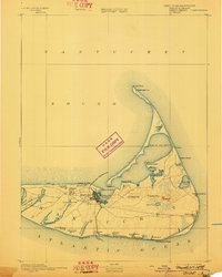
1893 Map of Nantucket
USGS Topo · Published 1893About this map
Nantucket town serves as the primary hub on this late nineteenth-century survey, its streets radiating toward the harbor and the Nantucket Railroad. The rail line provides a vital link across the island’s interior, connecting the main settlement with the coastal communities of Surfside and Siasconsett. Along the northern coast, the intricate geography of Coatue Beach and Head of the Harbor is carefully delineated, punctuated by maritime navigational aids such as the Brant Point Lt. and the Nantucket Cliff Beacons.
Find a feature on this map
48 named features on this map. Tap any name to fly to it.
Don’t see what you’re looking for? This feature index may not catch every label — zoom into the map to look around manually.
Map Details
Editions of this 1893 Nantucket Map
2 editions found
Other maps of this area

1887 · Muskeget
USGS Topo · 1:62,500

1889 · Muskeget
USGS Topo · 1:62,500

1889 · Nantucket
USGS Topo · 1:62,500

1893 · Muskeget
USGS Topo · 1:62,500

1899 · Muskeget
USGS Topo · 1:62,500

1901 · Nantucket
USGS Topo · 1:62,500

1942 · Nantucket
USGS Topo · 1:125,000

1945 · Nantucket
USGS Topo · 1:31,680

1945 · Siasconset
USGS Topo · 1:31,680

1945 · Great Point
USGS Topo · 1:31,680