1983 Map of Napa
USGS Topo · Published 1983About this map
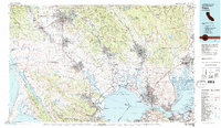
San Pablo Bay and its complex network of sloughs and straits anchor this early 1980s landscape, illustrating the regional connection between the Pacific coast and the inland agricultural valleys. The map documents a critical period of urban expansion for North Bay hubs like Santa Rosa, Napa, and Vallejo, while preserving the clear boundaries of the Point Reyes National Seashore and the San Andreas Rift Zone to the west.
Find a feature on this map
259 named features on this map. Tap any name to fly to it.
Don’t see what you’re looking for? This feature index may not catch every label — zoom into the map to look around manually.
Map Details
Editions of this 1983 Napa Map
This is the sole edition of this map. No revisions or reprints were ever made.
Other maps of this area

1895 · San Francisco
USGS Topo · 1:62,500

1896 · Carquinez Strait
USGS Topo · 1:62,500

1896 · Mt. Diablo
USGS Topo · 1:62,500

1897 · Concord
USGS Topo · 1:62,500

1897 · Tamalpais
USGS Topo · 1:62,500

1898 · Karquines
USGS Topo · 1:62,500

1898 · Mt. Diablo
USGS Topo · 1:62,500

1899 · San Francisco
USGS Topo · 1:62,500

1901 · Karquines
USGS Topo · 1:62,500

1902 · Napa
USGS Topo · 1:125,000