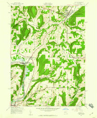
1942 Map of Naples
USGS Topo · Published 1960About this map
The village of Naples sits at the northern edge of this Finger Lakes region landscape, where Naples Creek and Tannery Creek converge near the Fairground. In the early 1940s, the area's rural character was defined by a dense network of numbered schoolhouses, including School No 2 and School No 12, and several high-elevation cemeteries such as Rose Ridge Cem and Gould Cem. To the south, the neighboring settlements of Atlanta and North Cohocton served as a transportation hub where the Erie and Delaware Lackawanna and Western railroads intersected along the Cohocton Creek valley. Significant topographic relief is visible between Hatch Hill and Pine Hill, while industrial footprints appear near the northeastern corner through several Gas Wells and the preserved lands of the High Tor Game Management Area.
Find a feature on this map
40 named features on this map. Tap any name to fly to it.
Don’t see what you’re looking for? This feature index may not catch every label — zoom into the map to look around manually.
Map Details
Editions of this 1942 Naples Map
4 editions found

Other maps of this area

1900 · Naples
USGS Topo · 1:62,500

1902 · Wayland
USGS Topo · 1:62,500

1903 · Naples
USGS Topo · 1:62,500

1904 · Wayland
USGS Topo · 1:62,500

1910 · Bath
USGS Topo · 1:62,500

1913 · Naples
USGS Topo · 1:62,500

1915 · Hornell
USGS Topo · 1:62,500

1918 · Hornell
USGS Topo · 1:62,500

1942 · Springwater
USGS Topo · 1:31,680

1942 · Wayland
USGS Topo · 1:31,680