1957 Map of Naranjito
USGS Topo · Published 1959About this map
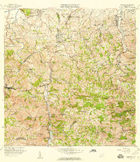
Naranjito serves as the focal point for this 1957 topographic study, situated where the Rio de la Plata carves a deep path through the interior highlands. The map illustrates a landscape transitioning from the more densely settled northern barrios of Pajaro and Van Scoy into the steep, church-dotted ridges of the south. Local life in the mid-1950s is anchored by numerous spiritual and educational sites, including the Iglesia Parroquial Corazon de Jesus and the Escuela Alto Dona Elena. The importance of water management for the region is evident in the infrastructure along the river, specifically the Represa de San Juan and Represa de Comerío. Numerous named creeks, such as Quebrada Cedrito and Quebrada Santa Olaya, drain the rugged terrain between peaks like Cerro Avispa and Cerro Gordo.
Find a feature on this map
83 named features on this map. Tap any name to fly to it.
Don’t see what you’re looking for? This feature index may not catch every label — zoom into the map to look around manually.
Map Details
Editions of this 1957 Naranjito Map
This is the sole edition of this map. No revisions or reprints were ever made.
Other maps of this area

1940 · Vega Alta
USGS Topo · 1:30,000

1941 · Bayamon
USGS Topo · 1:30,000

1941 · San Juan
USGS Topo · 1:30,000

1946 · Aguas Buenas
USGS Topo · 1:30,000

1946 · Corozal
USGS Topo · 1:30,000

1946 · Barranquitas
USGS Topo · 1:30,000

1946 · Vega Alta
USGS Topo · 1:30,000

1946 · Comerio
USGS Topo · 1:30,000

1946 · Naranjito
USGS Topo · 1:30,000

1946 · Caguas
USGS Topo · 1:30,000
Featured Places
- Naranjito, Naranjito
- Sector Correa, Naranjito
- Villas del Olimpo, Bayamón
- Sector La Capilla, Bayamón
- Sector González, Bayamón