
2023 Map of Narrowsburg
USGS Topo · Published 2023About this map
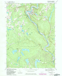
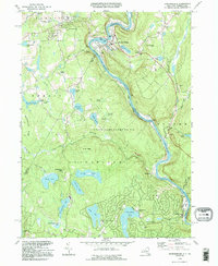
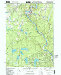
Narrowsburg and the winding Delaware River anchor this study of the borderlands between Sullivan Co New York and Wayne Co Pennsylvania. The river corridor is defined by the Upper Delaware Wild and Scenic River and its dramatic Delaware River Gorge, where the hamlet of Tusten sits at the foot of Tusten Mountain. This region is heavily dotted with water bodies and wetlands, from Wolf Lake and Panther Lake to the protected Spruce Swamp and Rowland Swamp. For genealogists, the map identifies several distinct burial sites including the Westcolang Burying Ground, Lava Cem, and Saint Francis Xavier Cem. The landscape transitions from the river valley to upland settlements like Atco and East Berlin, showing a complex network of forest roads and residential developments such as Fawn Lake Forest and Forest Lake Park.
Find a feature on this map
153 named features on this map. Tap any name to fly to it.
Don’t see what you’re looking for? This feature index may not catch every label — zoom into the map to look around manually.
Map Details
Editions of this 2023 Narrowsburg Map
This is the sole edition of this map. No revisions or reprints were ever made.
Historical Maps of Palmyra Township Through Time
4 maps found
Featured Locations
- Lackawaxen Township, PA
- Damascus Township, PA
- Tusten, NY
- Westcolang, Lackawaxen Township
- Narrowsburg, Tusten