
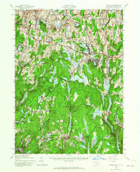
1943 Map of White Lake
USGS Topo · Published 1960About this map
The Bethel and Thompson countryside in the mid-1940s is defined by a dense network of mountain lakes and early 20th-century rural infrastructure. This map reveals a landscape heavily dependent on local schoolhouses, marking locations like Birch Ridge Sch, Wellstown Sch, and Lebanon Lake Sch across the uplands. The water-dominated topography includes the large Toronto Reservoir and Lake Superior, surrounded by smaller hamlets such as Kenoza Lake and Fosterdale. A clear shift from agricultural reliance to a recreation-based economy is evident in the cluster of settlements around White Lake and North White Lake. Researchers will find a preserved look at local connectivity through landmarks like Angel Mill Rd and various family-named ponds, alongside established communities like the Dutch Settlement in the southeast corner of the quadrangle.
Find a feature on this map
95 named features on this map. Tap any name to fly to it.
Don’t see what you’re looking for? This feature index may not catch every label — zoom into the map to look around manually.
Map Details
Editions of this 1943 White Lake Map
2 editions found
Other maps of this area

1906 · Port Jervis
USGS Topo · 1:62,500

1908 · Port Jervis
USGS Topo · 1:62,500

1909 · Monticello
USGS Topo · 1:62,500

1910 · Neversink
USGS Topo · 1:62,500

1911 · Monticello
USGS Topo · 1:62,500

1913 · Milford
USGS Topo · 1:62,500

1915 · Milford
USGS Topo · 1:62,500

1920 · Long Eddy
USGS Topo · 1:62,500

1920 · Damascus
USGS Topo · 1:62,500

1921 · Long Eddy
USGS Topo · 1:48,000