
1939 Map of Nash Draw
USGS Topo · Published 1971About this map
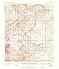
Industrial potash mining and isolated ranching operations define this arid New Mexico landscape during the late 1930s. The northern reaches are dominated by the heavy machinery of the U.S. Potash Co Mine and the International Mineral & Chemical Corp Mine, connected to the wider world via the Atchison Topeka and Santa Fe Railroad. These industrial sites stand in contrast to the expansive, water-scarce terrain of Nash Draw and the nearby Salt Lake.
Find a feature on this map
26 named features on this map. Tap any name to fly to it.
Don’t see what you’re looking for? This feature index may not catch every label — zoom into the map to look around manually.
Map Details
Editions of this 1939 Nash Draw Map
2 editions found
Other maps of this area

1939 · Carlsbad
USGS Topo · 1:62,500

1942 · Clayton Basin
USGS Topo · 1:62,500

1943 · Carlsbad
USGS Topo · 1:62,500

1943 · Clayton Basin
USGS Topo · 1:62,500

1943 · Oil City
USGS Topo · 1:62,500

1943 · Nash Draw
USGS Topo · 1:62,500

1945 · Malaga
USGS Topo · 1:62,500

1946 · Malaga
USGS Topo · 1:62,500

1954 · Carlsbad
USGS Topo · 1:250,000

1954 · Hobbs
USGS Topo · 1:250,000