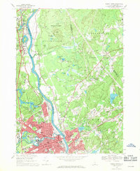
1968 Map of Nashua North
USGS Topo · Published 1971About this map
The Merrimack River serves as the central artery of this landscape, dividing the urban expansion of Nashua and Hudson from the rural woodlands of Litchfield. In the late 1960s, the western bank shows the burgeoning infrastructure of the F. E. Everett Highway alongside industrial corridors and dense residential blocks. Conversely, the eastern side retains a significant amount of undeveloped land within the Litchfield State Forest and agricultural tracts punctuated by family-named landmarks like Thorntons Ferry.
Find a feature on this map
87 named features on this map. Tap any name to fly to it.
Don’t see what you’re looking for? This feature index may not catch every label — zoom into the map to look around manually.
Map Details
Editions of this 1968 Nashua North Map
Other maps of this area

1886 · Lowell
USGS Topo · 1:62,500

1893 · Lowell
USGS Topo · 1:62,500

1893 · Groton
USGS Topo · 1:62,500

1905 · Manchester
USGS Topo · 1:62,500

1906 · Milford
USGS Topo · 1:62,500

1918 · Lowell
USGS Topo · 1:62,500

1921 · Lowell
USGS Topo · 1:62,500

1931 · Lowell
USGS Topo · 1:48,000

1931 · Groton
USGS Topo · 1:48,000

1935 · Groton
USGS Topo · 1:62,500