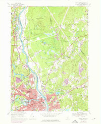
1968 Map of Nashua North
USGS Topo · Published 1976About this map
The Merrimack River serves as the central artery for this region, separating the industrial core of Nashua and Hudson from the agricultural and forested stretches of Litchfield. In the late 1960s, the landscape shows a mix of dense urban development and pockets of rural tradition, where numerous cemeteries like Hills Farms Cem and Hillcrest Cem preserve the names of early settler families. Institutional presence is strong in Nashua, marked by several Catholic schools and religious centers including St Francis Xavier Academie and Mt St Marys Seminary. The rail-centered economy is still visible via the Boston and Maine corridor, though the burgeoning Everett Turnpike signals the shift toward modern highway transit. To the north, the Litchfield State Forest and various ponds like Robinson Pond and Half Moon Pond provide a contrast to the gravel pits and expanding residential tracts near Potash Corner.
Find a feature on this map
116 named features on this map. Tap any name to fly to it.
Don’t see what you’re looking for? This feature index may not catch every label — zoom into the map to look around manually.
Map Details
Editions of this 1968 Nashua North Map
Other maps of this area

1886 · Lowell
USGS Topo · 1:62,500

1893 · Lowell
USGS Topo · 1:62,500

1893 · Groton
USGS Topo · 1:62,500

1905 · Manchester
USGS Topo · 1:62,500

1906 · Milford
USGS Topo · 1:62,500

1918 · Lowell
USGS Topo · 1:62,500

1921 · Lowell
USGS Topo · 1:62,500

1931 · Lowell
USGS Topo · 1:48,000

1931 · Groton
USGS Topo · 1:48,000

1935 · Groton
USGS Topo · 1:62,500