1972 Map of Nashua
USGS Topo · Published 1976About this map
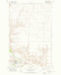
Nashua sits at the southern edge of this Valley County landscape, positioned where the Burlington Northern railroad meets the winding course of the Milk River. The settlement is defined by its role as a local transport hub, featuring a Landing Strip and proximity to the Fort Peck Indian Reservation Boundary, which runs just north and west of the town site. The terrain shifts dramatically from the river bottomlands into the Milk River Hills, where the drainage of Ivy Coulee and Porcupine Creek carve through the northern plateau.
Find a feature on this map
20 named features on this map. Tap any name to fly to it.
Don’t see what you’re looking for? This feature index may not catch every label — zoom into the map to look around manually.
Map Details
Editions of this 1972 Nashua Map
This is the sole edition of this map. No revisions or reprints were ever made.
Other maps of this area

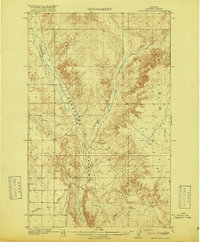
1914 · Nashua
USGS Topo · 1:62,500

1915 · Frazer
USGS Topo · 1:62,500

1915 · Spring Creek
USGS Topo · 1:62,500

1916 · Nashua
USGS Topo · 1:62,500
1918 · Porcupine Valley
USGS Topo · 1:62,500

1954 · Glasgow
USGS Topo · 1:250,000

1957 · Glasgow
USGS Topo · 1:250,000

1958 · Glasgow
USGS Topo · 1:250,000
1972 · Milk River Coulee
USGS Topo · 1:24,000
1972 · Milk River Hills
USGS Topo · 1:24,000