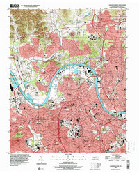
1997 Map of Nashville West
USGS Topo · Published 1999About this map
The Cumberland River carves a deep arc through the heart of this landscape, separating the dense urban grid of Nashville from the rising hills and northern suburbs of Bordeaux and Jordonia. This late-twentieth-century perspective reveals a city defined by its institutional legacy, notably the concentration of prominent educational and medical centers like Meharry Medical College, Fisk University, and Vanderbilt University. The industrial and civic evolution of the riverfront is visible near Cheatham + Lake, where the CSX Transportation lines and major arteries like Charlotte Ave intersect with historical landmarks including the State Penitentiary and the State Prison for Women. Local history is deeply embedded in the numerous cemeteries and religious sites, from the City Cem and Mt Ararat Cem in the south to St Marys Orphanage and Whites Creek Ch in the outlying districts.
Find a feature on this map
65 named features on this map. Tap any name to fly to it.
Don’t see what you’re looking for? This feature index may not catch every label — zoom into the map to look around manually.
Map Details
Editions of this 1997 Nashville West Map
This is the sole edition of this map. No revisions or reprints were ever made.
Other maps of this area

1903 · Nashville
USGS Topo · 1:125,000

1931 · Ridgetop
USGS Topo · 1:62,500

1932 · Hermitage
USGS Topo · 1:62,500

1932 · Nashville
USGS Topo · 1:62,500

1935 · Ridgetop
USGS Topo · 1:62,500

1942 · Gallatin
USGS Topo · 1:100,000

1942 · Lebanon
USGS Topo · 1:100,000

1952 · Goodlettsville
USGS Topo · 1:24,000

1952 · Nashville West
USGS Topo · 1:24,000

1952 · Nashville East
USGS Topo · 1:24,000