
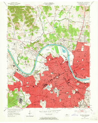
1952 Map of Nashville West
USGS Topo · Published 1954About this map
The Cumberland River carves a deep oxbow through this mid-century landscape, separating the dense urban core from the developing outskirts of Bordeaux and Jordonia. This era reveals a city defined by its institutional and educational pillars, with Fisk University, Meharry Medical College, and the Agricultural and Industrial State University established as major landmarks in the western reaches. The infrastructure of the period is highly visible, from the State Penitentiary along the riverbanks to the network of rail lines like the Louisville and Nashville Railroad that fueled the regional economy.
Find a feature on this map
135 named features on this map. Tap any name to fly to it.
Don’t see what you’re looking for? This feature index may not catch every label — zoom into the map to look around manually.
Map Details
Editions of this 1952 Nashville West Map
2 editions found
Other maps of this area

1903 · Nashville
USGS Topo · 1:125,000

1931 · Ridgetop
USGS Topo · 1:62,500

1932 · Hermitage
USGS Topo · 1:62,500

1932 · Nashville
USGS Topo · 1:62,500

1935 · Ridgetop
USGS Topo · 1:62,500

1942 · Gallatin
USGS Topo · 1:100,000

1942 · Lebanon
USGS Topo · 1:100,000

1952 · Goodlettsville
USGS Topo · 1:24,000

1952 · Nashville East
USGS Topo · 1:24,000

1952 · Antioch
USGS Topo · 1:24,000