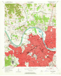
1952 Map of Nashville West
USGS Topo · Published 1964About this map
Nashville is depicted as a dense urban core bounded by the winding Cumberland River, revealing the city's mid-century expansion and its concentrated institutional landscape. The western districts are defined by a high density of medical and educational centers, including the historic campuses of Fisk University, Meharry Medical College, and the Agricultural and Industrial State University. The map documents the intricate rail infrastructure of the Louisville and Nashville RR and the Tennessee Central RR as they converge near the State Capitol. Beyond the city's red-tinted urban limits, the terrain transitions into the hills of the Cockrill Bend, where the State Penitentiary stands in isolation. This survey captures a moment when the city's growth was pushing toward communities like Bordeaux and Brooklyn Heights, while still retaining open spaces like Cumberland Airfield and numerous named parks and neighborhood schools that would anchor future suburban development.
Find a feature on this map
155 named features on this map. Tap any name to fly to it.
Don’t see what you’re looking for? This feature index may not catch every label — zoom into the map to look around manually.
Map Details
Editions of this 1952 Nashville West Map
2 editions found
Other maps of this area

1903 · Nashville
USGS Topo · 1:125,000

1931 · Ridgetop
USGS Topo · 1:62,500

1932 · Hermitage
USGS Topo · 1:62,500

1932 · Nashville
USGS Topo · 1:62,500

1935 · Ridgetop
USGS Topo · 1:62,500

1942 · Gallatin
USGS Topo · 1:100,000

1942 · Lebanon
USGS Topo · 1:100,000

1952 · Goodlettsville
USGS Topo · 1:24,000

1952 · Nashville West
USGS Topo · 1:24,000

1952 · Nashville East
USGS Topo · 1:24,000