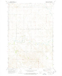
1974 Map of Nason Hill
USGS Topo · Published 1978About this map
Nason Hill rises above the confluence of prairie drainages in this 1974 topographic survey of Adams County. The landscape is defined by the winding paths of Timber Creek, Cedar Creek, and Plum Creek, which cut through the high plains terrain. Local family history is centered on the Stowers Cem and Cedar Creek Cem, small burial grounds that mark the settlement patterns of this rural ranching and farming district. Evidence of early industry and infrastructure appears in the form of multiple Gravel Pit sites scattered across the landscape, serving the needs of the local road network. Near the southern boundary, the map records the small locality of Beesley, situated just north of the Standing Rock Indian Reservation boundary. The map provides a clear look at the township and section lines that organized the North Dakota prairie, showing the relationship between natural watercourses and the established political borders of the era.
Find a feature on this map
14 named features on this map. Tap any name to fly to it.
Don’t see what you’re looking for? This feature index may not catch every label — zoom into the map to look around manually.
Map Details
Editions of this 1974 Nason Hill Map
This is the sole edition of this map. No revisions or reprints were ever made.
Other maps of this area

1953 · McIntosh
USGS Topo · 1:250,000

1953 · Dickinson
USGS Topo · 1:250,000

1954 · Lemmon
USGS Topo · 1:250,000

1954 · Bismarck
USGS Topo · 1:250,000

1957 · Dickinson
USGS Topo · 1:250,000

1957 · Lemmon
USGS Topo · 1:250,000

1958 · Bismarck
USGS Topo · 1:250,000

1958 · McIntosh
USGS Topo · 1:250,000

1972 · Coffin Buttes
USGS Topo · 1:24,000

1972 · Round Top
USGS Topo · 1:24,000