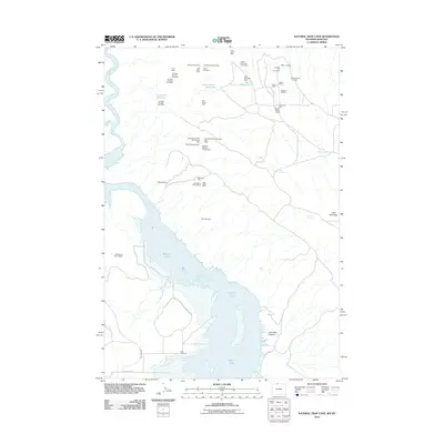
2011 Map of Natural Trap Cave
USGS Topo · Published 2011About this map
Bighorn Lake dominates the southern portion of this landscape at the Montana-Wyoming border, where the waters of the Bighorn River are impounded. The terrain is marked by a dense concentration of mining claims and operations clustered in the north, including the Fuesner and Sons Mine, Lisbon Mines, and the notably named Dirty Beast Mine. This 2011 survey reveals an industrial landscape tied to resource extraction, with numerous small-scale operations like the Tri Pacer Number Five Mine scattered across the high ground near Cedar Buttes Reservoir. Near the southern shore, the Kane Cemetery stands as a quiet landmark of the area's earlier human history, situated just off County Hwy 8 1/2. The mapping detail extends through John Blue Canyon and up toward the slopes of Little Mountain, illustrating the intersection of modern recreation and legacy mining works.
Find a feature on this map
41 named features on this map. Tap any name to fly to it.
Don’t see what you’re looking for? This feature index may not catch every label — zoom into the map to look around manually.
Map Details
Editions of this 2011 Natural Trap Cave Map
This is the sole edition of this map. No revisions or reprints were ever made.
Other maps of this area

1954 · Billings
USGS Topo · 1:250,000

1955 · Cody
USGS Topo · 1:250,000

1957 · Billings
USGS Topo · 1:250,000

1958 · Billings
USGS Topo · 1:250,000

1958 · Cody
USGS Topo · 1:250,000

1962 · Cody
USGS Topo · 1:250,000

1964 · Kane
USGS Topo · 1:24,000

1964 · Two Point
USGS Topo · 1:24,000
1964 · Simmons Canyon
USGS Topo · 1:24,000

1964 · Lovell Lakes
USGS Topo · 1:24,000