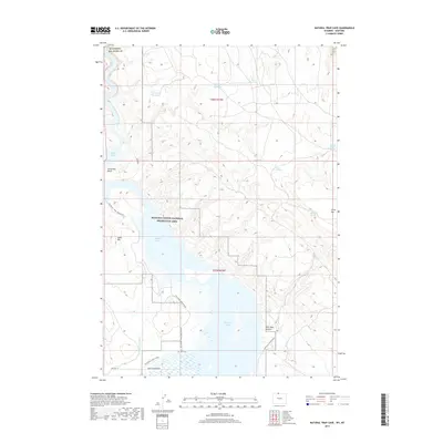
2017 Map of Natural Trap Cave
USGS Topo · Published 2017About this map
Bighorn Canyon National Recreation Area dominates this high-plains landscape where the Montana-Wyoming border meets the rising slopes of Little Mtn. The terrain is defined by the expansive Bighorn Lake, which fills the deep canyons between Sykes Mtn and the eastern ridges. Along the southern shores, the map reveals traces of local history near the Kane Cem and the small settlements of Iona and Kane, situated near the Big Fork Canal. This 2017 survey details a network of specialized access routes including the Yellowtail-Kane Cemetary Rd and Habitat Burn Roads, reflecting modern land management and conservation efforts. Scattered water sources like School Section Spring and Lone Hill Reservoir highlight the arid nature of the surrounding uplands, while the ancient route of Bad Pass suggests the long-standing significance of this corridor through the canyon country.
Find a feature on this map
26 named features on this map. Tap any name to fly to it.
Don’t see what you’re looking for? This feature index may not catch every label — zoom into the map to look around manually.
Map Details
Editions of this 2017 Natural Trap Cave Map
This is the sole edition of this map. No revisions or reprints were ever made.
Other maps of this area

1954 · Billings
USGS Topo · 1:250,000

1955 · Cody
USGS Topo · 1:250,000

1957 · Billings
USGS Topo · 1:250,000

1958 · Billings
USGS Topo · 1:250,000

1958 · Cody
USGS Topo · 1:250,000

1962 · Cody
USGS Topo · 1:250,000

1964 · Kane
USGS Topo · 1:24,000

1964 · Two Point
USGS Topo · 1:24,000
1964 · Simmons Canyon
USGS Topo · 1:24,000

1964 · Lovell Lakes
USGS Topo · 1:24,000