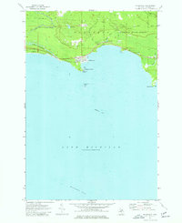
1973 Map of Naubinway
USGS Topo · Published 1977About this map
The northern shores of Lake Michigan define this coastal landscape, where the fishing and logging village of Naubinway serves as a primary hub for the region. The interior is largely dominated by the Mackinac State Forest, a terrain marked by numerous watercourses including the Lower Millecoquins River, East Mile Creek, and Mattis Creek. Inland, the map reveals industrial and recreational infrastructure such as a Compressor Station, multiple sandpits, and a Golf Course near the town center.
Find a feature on this map
26 named features on this map. Tap any name to fly to it.
Don’t see what you’re looking for? This feature index may not catch every label — zoom into the map to look around manually.
Map Details
Editions of this 1973 Naubinway Map
This is the sole edition of this map. No revisions or reprints were ever made.
Other maps of this area

1931 · Gould City NE
USGS Topo · 1:31,680

1931 · Gould City SE
USGS Topo · 1:31,680

1931 · Gilchrist NE
USGS Topo · 1:31,680

1931 · Gilchrist NW
USGS Topo · 1:31,680

1954 · Sault Sainte Marie
USGS Topo · 1:250,000

1955 · Hog Island
USGS Topo · 1:62,500

1955 · Cheboygan
USGS Topo · 1:250,000

1956 · Sault Sainte Marie
USGS Topo · 1:250,000

1957 · Sault Sainte Marie
USGS Topo · 1:250,000

1958 · Cheboygan
USGS Topo · 1:250,000