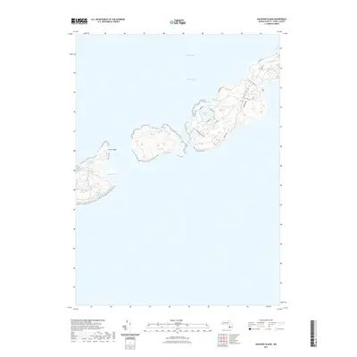
2021 Map of Naushon Island
USGS Topo · Published 2021About this map
Buzzards Bay surrounds the Elizabeth Islands in this detailed topographic study of a coastal landscape. The map emphasizes the isolation and natural composition of the islands, defined by inland water bodies such as Westend Pond and Blaney Pond. A network of unpaved tracks and paths, including Western Hills Path and Rambler Path, provides the primary means of navigation across the interior terrain. On the southern edge of the chain, Quicks Hole Pond sits near the passage between islands, while marine hazards like Felix Ledge are noted just offshore. The scarcity of residential development is reflected in the simple naming of routes like N Main Rd and S Bluff Rd, suggesting a landscape largely preserved for conservation or private seasonal use. This 2021 update documents the current elevation and hydrological state of these unique landforms within Dukes County.
Find a feature on this map
18 named features on this map. Tap any name to fly to it.
Don’t see what you’re looking for? This feature index may not catch every label — zoom into the map to look around manually.
Map Details
Editions of this 2021 Naushon Island Map
This is the sole edition of this map. No revisions or reprints were ever made.
Other maps of this area

1885 · New Bedford
USGS Topo · 1:62,500

1886 · Falmouth
USGS Topo · 1:62,500

1887 · Gay Head
USGS Topo · 1:62,500

1888 · New Bedford
USGS Topo · 1:62,500

1888 · Falmouth
USGS Topo · 1:62,500

1889 · Gay Head
USGS Topo · 1:62,500

1893 · Gay Head
USGS Topo · 1:62,500

1893 · Falmouth
USGS Topo · 1:62,500

1893 · New Bedford
USGS Topo · 1:62,500

1915 · Falmouth
USGS Topo · 1:62,500