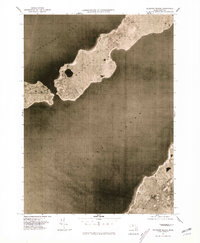
1977 Map of Naushon Island
USGS Topo · Published 1981About this map
Naushon Island and the southwestern reach of the Elizabeth Islands appear here as captured by aerial photography in the late 1970s. This orthophotoquad provides a clear view of the coastal morphology between Buzzards Bay and Vineyard Sound, documenting the shoreline and vegetation patterns of this isolated chain. Notable landmarks include the prominent Mt Surat and the sheltered Westend Pond on the western end of the main island. To the southwest, Pasque Island is visible across the narrow channel, while the northwestern edge of Marthas Vineyard occupies the lower right corner of the sheet. The absence of roads and modern development in this view highlights the preservation of the landscape during this era, serving as a baseline for coastal researchers and local historians.
Find a feature on this map
8 named features on this map. Tap any name to fly to it.
Don’t see what you’re looking for? This feature index may not catch every label — zoom into the map to look around manually.
Map Details
Editions of this 1977 Naushon Island Map
This is the sole edition of this map. No revisions or reprints were ever made.
Other maps of this area

1885 · New Bedford
USGS Topo · 1:62,500

1886 · Falmouth
USGS Topo · 1:62,500

1887 · Gay Head
USGS Topo · 1:62,500

1888 · New Bedford
USGS Topo · 1:62,500

1888 · Falmouth
USGS Topo · 1:62,500

1889 · Gay Head
USGS Topo · 1:62,500

1893 · Gay Head
USGS Topo · 1:62,500

1893 · Falmouth
USGS Topo · 1:62,500

1893 · New Bedford
USGS Topo · 1:62,500

1915 · Falmouth
USGS Topo · 1:62,500