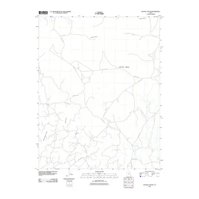
2010 Map of Navajo Canyon
USGS Topo · Published 2010About this map
Aneth Oil Field anchors the southern portion of this landscape, reflecting the industrial footprint of energy extraction in southeastern Utah. The terrain is defined by the significant drainage of Navajo Canyon and the broad expanse of Cajon Mesa, where a network of regional and reservation roads facilitates movement across the high desert. To the west, the deeply incised Allen Canyon and West Fork Allen Canyon lead toward the waters of Montezuma Creek. The transportation network is notably specialized, featuring numerous spurs and connectors such as Old Aneth Rd, Old Aneth Cutoff, and Ismay Loop Rd that serve both the local community and the oil fields. This 2010 survey illustrates the coexistence of traditional reservation lands and modern industrial activity through its intricate grid of improved and unimproved routes.
Find a feature on this map
17 named features on this map. Tap any name to fly to it.
Don’t see what you’re looking for? This feature index may not catch every label — zoom into the map to look around manually.
Map Details
Editions of this 2010 Navajo Canyon Map
This is the sole edition of this map. No revisions or reprints were ever made.
Other maps of this area

1886 · Abajo
USGS Topo · 1:250,000

1892 · Abajo
USGS Topo · 1:250,000

1893 · Abajo
USGS Topo · 1:250,000

1956 · Cortez
USGS Topo · 1:250,000

1957 · Aneth 1 NE
USGS Topo · 1:24,000

1957 · Aneth 1 NW
USGS Topo · 1:24,000

1958 · Cortez
USGS Topo · 1:250,000

1958 · Aneth 1 SW
USGS Topo · 1:24,000
1958 · Aneth 1 SE
USGS Topo · 1:24,000

1958 · Cajon Mesa
USGS Topo · 1:62,500