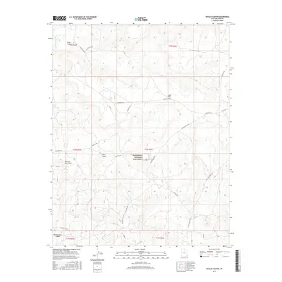
2017 Map of Navajo Canyon
USGS Topo · Published 2017About this map
Hovenweep National Monument serves as the focal point of this high-desert landscape, preserving the remains of ancient stone towers and ancestral Puebloan dwellings. Situated atop Cajon Mesa, the monument is surrounded by a rugged network of drainages including Allen Canyon and the winding path of Navajo Canyon. The terrain is characterized by these deep incisions into the plateau, where the West Fork Allen Canyon meets the main branch amidst a series of township and range divisions. Cultural history is reflected in the naming of travel routes like Ismay Trading Post Rd and the Old Aneth Rd, which cross the mesa to connect remote outposts. Along the southern edge, Montezuma Creek flows through the territory, a vital water source in this arid corner of San Juan County where reservation boundaries and local ranch roads intersect.
Find a feature on this map
30 named features on this map. Tap any name to fly to it.
Don’t see what you’re looking for? This feature index may not catch every label — zoom into the map to look around manually.
Map Details
Editions of this 2017 Navajo Canyon Map
This is the sole edition of this map. No revisions or reprints were ever made.
Other maps of this area

1886 · Abajo
USGS Topo · 1:250,000

1892 · Abajo
USGS Topo · 1:250,000

1893 · Abajo
USGS Topo · 1:250,000

1956 · Cortez
USGS Topo · 1:250,000

1957 · Aneth 1 NE
USGS Topo · 1:24,000

1957 · Aneth 1 NW
USGS Topo · 1:24,000

1958 · Cortez
USGS Topo · 1:250,000

1958 · Aneth 1 SW
USGS Topo · 1:24,000
1958 · Aneth 1 SE
USGS Topo · 1:24,000

1958 · Cajon Mesa
USGS Topo · 1:62,500