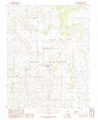
1985 Map of Navajo Canyon
USGS Topo · Published 1985About this map
Navajo Indian Reservation lands dominate this high desert landscape on the border of Utah and Colorado, where ancient archaeological history meets the mid-century energy economy. The terrain is defined by the high, flat surface of Cajon Mesa, deeply incised by the drainage systems of Navajo Canyon and Montezuma Creek. A portion of the Hovenweep National Monument is preserved here, protecting ancestral Puebloan sites within the winding canyons. Beyond the cultural ruins, the map records the modern pulse of the region through numerous oil and gas wells and a network of unimproved roads. Small markers such as a Cem and isolated tanks suggest the sparse human presence in this arid corner of San Juan County during the late 1970s.
Find a feature on this map
8 named features on this map. Tap any name to fly to it.
Don’t see what you’re looking for? This feature index may not catch every label — zoom into the map to look around manually.
Map Details
Editions of this 1985 Navajo Canyon Map
This is the sole edition of this map. No revisions or reprints were ever made.
Other maps of this area

1886 · Abajo
USGS Topo · 1:250,000

1892 · Abajo
USGS Topo · 1:250,000

1893 · Abajo
USGS Topo · 1:250,000

1956 · Cortez
USGS Topo · 1:250,000

1957 · Aneth 1 NE
USGS Topo · 1:24,000

1957 · Aneth 1 NW
USGS Topo · 1:24,000

1958 · Cortez
USGS Topo · 1:250,000

1958 · Aneth 1 SW
USGS Topo · 1:24,000
1958 · Aneth 1 SE
USGS Topo · 1:24,000

1958 · Cajon Mesa
USGS Topo · 1:62,500