1959 Map of Navajo Dam
USGS Topo · Published 1968About this map
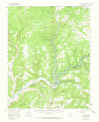
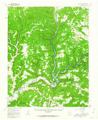
Navajo Dam stands as the central engineering feat of this 1950s landscape, captured just as the Navajo Reservoir began to transform the confluence of the Los Pinos River and the San Juan River. The map meticulously records the transition from a river-valley economy to a managed water system, noting areas subject to controlled inundation and the emergence of Navajo City. While modern infrastructure like the Landing Strip and various pipelines appear, the map also preserves traces of much older habitation, including a Cliff Dwelling and a small Cem near the dam site.
Find a feature on this map
46 named features on this map. Tap any name to fly to it.
Don’t see what you’re looking for? This feature index may not catch every label — zoom into the map to look around manually.
Map Details
Editions of this 1959 Navajo Dam Map
2 editions found
Other maps of this area

1889 · Largo
USGS Topo · 1:250,000

1895 · Largo
USGS Topo · 1:250,000

1908 · Ignacio
USGS Topo · 1:125,000

1924 · Ignacio
USGS Topo · 1:125,000

1924 · Pagosa Springs
USGS Topo · 1:125,000

1927 · Pagosa Springs
USGS Topo · 1:125,000

1945 · Durango
USGS Topo · 1:250,000

1953 · Durango
USGS Topo · 1:250,000

1954 · Durango
USGS Topo · 1:250,000
1954 · Allison
USGS Topo · 1:24,000