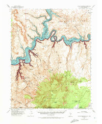
1953 Map of Navajo Mountain
USGS Topo · Published 1973About this map
Navajo Mountain dominates the southern landscape of this 1953 survey, a prominent landmark rising above the Navajo Plateau within the Navajo Indian Reservation. The map captures a critical period of geographic transition, showing the Colorado River and San Juan River before the full impact of river management transformed the canyons. The inclusion of Lake Powell as a blue-tinted overlay reflects minor corrections made in the early 1970s, documenting the inundation of Glen Canyon.
Find a feature on this map
42 named features on this map. Tap any name to fly to it.
Don’t see what you’re looking for? This feature index may not catch every label — zoom into the map to look around manually.
Map Details
Editions of this 1953 Navajo Mountain Map
3 editions found

Other maps of this area

1883 · Marsh Pass
USGS Topo · 1:250,000

1886 · Escalante
USGS Topo · 1:250,000

1886 · Henry Mountains
USGS Topo · 1:250,000

1886 · Echo Cliffs
USGS Topo · 1:250,000

1891 · Echo Cliffs
USGS Topo · 1:250,000

1892 · Marsh Pass
USGS Topo · 1:250,000

1892 · Henry Mountains
USGS Topo · 1:250,000

1953 · Navajo Mountain 4 NW
USGS Topo · 1:24,000

1953 · Navajo Mountain 4 SW
USGS Topo · 1:24,000

1953 · Cummings Mesa
USGS Topo · 1:62,500