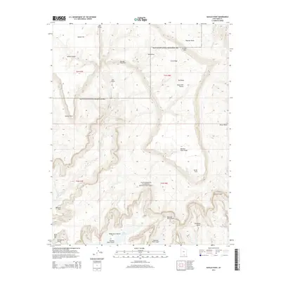
2014 Map of Navajo Point
USGS Topo · Published 2014About this map
Kaiparowits Plateau and the Straight Cliffs dominate this high-desert landscape in southern Utah, marking the stark transition from elevated tablelands to the deeply incised drainages feeding into Lake Powell. This 2014 survey captures a section of the Glen Canyon National Recreation Area characterized by dramatic vertical relief and traditional western nomenclature. Named landmarks like Teddys Horse Pasture, Harveys Fear Cliff, and Billie Flat Top suggest a history of cattle ranching and early exploration across these challenging benches. The topography reveals a complex network of dry washes and springs, including Dry Rock Cr and East End Spring, which are critical water sources in this arid environment. Strategic overlooks such as Navajo Point and Spencer Point provide vantage points across the labyrinth of corridors like Dangling Rope Canyon and Cascade Canyon.
Find a feature on this map
30 named features on this map. Tap any name to fly to it.
Don’t see what you’re looking for? This feature index may not catch every label — zoom into the map to look around manually.
Map Details
Editions of this 2014 Navajo Point Map
This is the sole edition of this map. No revisions or reprints were ever made.
Other maps of this area

1886 · Escalante
USGS Topo · 1:250,000

1886 · Henry Mountains
USGS Topo · 1:250,000

1892 · Henry Mountains
USGS Topo · 1:250,000

1953 · Cummings Mesa
USGS Topo · 1:62,500

1953 · The Rincon
USGS Topo · 1:62,500

1953 · Navajo Mountain
USGS Topo · 1:62,500

1956 · Escalante
USGS Topo · 1:250,000

1960 · Escalante
USGS Topo · 1:250,000
1968 · Blackburn Canyon
USGS Topo · 1:24,000
1968 · Sooner Bench
USGS Topo · 1:24,000