
1964 Map of Navarre
USGS Topo · Published 1965About this map
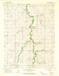
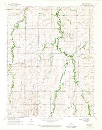
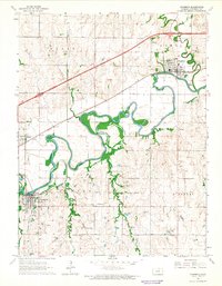
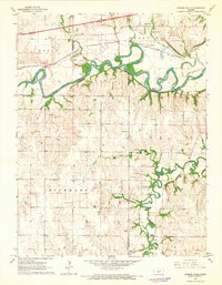
Navarre and the small siding of Pearl serve as central points in this mid-1960s survey of central Kansas. Two major rail systems, the Atchison Topeka and Santa Fe and the Chicago Rock Island and Pacific, cut across the landscape, illustrating the critical role of the railroad in moving agricultural goods from Dickinson County. The terrain is defined by a network of drainage systems, including the winding Carry Creek and Deer Creek, which carve through the townships of Logan, Liberty, and Rinehart. Local history and genealogy interests are anchored by the Scheiller Cem in the northwest and Riffel Cem to the east. Sparse industrial markers like a Drill Hole and a Quarry appear alongside rural infrastructure such as a Water Tank and Radio Tower, reflecting the quiet transition of this farming region during the mid-century era.
Find a feature on this map
23 named features on this map. Tap any name to fly to it.
Don’t see what you’re looking for? This feature index may not catch every label — zoom into the map to look around manually.
Map Details
Editions of this 1964 Navarre Map
This is the sole edition of this map. No revisions or reprints were ever made.
Other maps of this area

1889 · Abilene
USGS Topo · 1:125,000

1889 · Parkerville
USGS Topo · 1:125,000

1894 · Abilene
USGS Topo · 1:125,000

1894 · Parkerville
USGS Topo · 1:125,000

1955 · Hutchinson
USGS Topo · 1:250,000

1959 · Hutchinson
USGS Topo · 1:250,000
1963 · Abilene SW
USGS Topo · 1:24,000
1964 · Elmo
USGS Topo · 1:24,000
1964 · Chapman
USGS Topo · 1:24,000
1964 · Kansas Falls
USGS Topo · 1:24,000