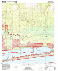
1994 Map of Navarre
USGS Topo · Published 1999About this map
Navarre and Wynnehaven Beach sit at the center of this coastal landscape, situated between the sprawling northern terrain of Eglin Air Force Base and the protected barrier of the Gulf Islands National Seashore. The geography is defined by the winding course of the East Bay River as it flows toward East Bay Swamp, a stark contrast to the straight passage of the Intracoastal Waterway through The Narrows. Military influence is evident across the northern half of the quadrangle, where Panther Creek and Prairie Creek drain a landscape of 4wd tracks and dedicated facilities like a Heliport and Landing Strip. Along the shoreline, markers like Lower Pritchard Long Pt and Manatee Pt identify the shifting sands and Tidal Flat regions characteristic of this portion of the Florida Panhandle.
Find a feature on this map
32 named features on this map. Tap any name to fly to it.
Don’t see what you’re looking for? This feature index may not catch every label — zoom into the map to look around manually.
Map Details
Editions of this 1994 Navarre Map
This is the sole edition of this map. No revisions or reprints were ever made.
Other maps of this area

1921 · Holley
USGS Topo · 1:62,500

1934 · Holt
USGS Topo · 1:48,000

1934 · Harold
USGS Topo · 1:62,500

1936 · Holley
USGS Topo · 1:48,000

1937 · Holt
USGS Topo · 1:62,500

1937 · Harold
USGS Topo · 1:62,500

1938 · Mary Esther
USGS Topo · 1:62,500

1938 · Holley
USGS Topo · 1:62,500

1938 · Harold
USGS Topo · 1:62,500

1956 · Fort Walton Beach
USGS Topo · 1:62,500