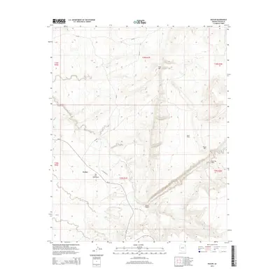
2014 Map of Nazlini
USGS Topo · Published 2014About this map
Nazlini anchors this landscape in the heart of the Navajo Nation, where the settlement is defined by the winding course of Nazlini Creek. The terrain is characterized by a series of high-altitude landmarks, including the prominent Gray Mtn and the flat-topped Rock Mesa. In the lower elevations, the drainage network is extensive, featuring Tah-alth-cheed Wash and Tse Deeshzhaai Wash cutting through the high desert floor. The transition into Nazlini Canyon reveals the dramatic vertical relief of the region, while the presence of Tsegito Spring provides a rare localized water source in this arid environment. Transportation through this remote section of Apache County is primarily facilitated by Bureau of Indian Affairs routes like Bia-27 and utility corridors such as Gas Pipeline Rd, which trace the contours of the mesas and canyons.
Find a feature on this map
23 named features on this map. Tap any name to fly to it.
Don’t see what you’re looking for? This feature index may not catch every label — zoom into the map to look around manually.
Map Details
Editions of this 2014 Nazlini Map
This is the sole edition of this map. No revisions or reprints were ever made.
Other maps of this area

1886 · Fort Defiance
USGS Topo · 1:250,000

1892 · Fort Defiance
USGS Topo · 1:250,000

1892 · Canyon De Chelly
USGS Topo · 1:250,000

1954 · Shiprock
USGS Topo · 1:250,000

1954 · Gallup
USGS Topo · 1:250,000

1955 · Zith-Tusayan Butte 2 SE
USGS Topo · 1:24,000

1955 · Zith-Tusayan Butte 2 SW
USGS Topo · 1:24,000

1955 · Zith-Tusayan Butte 2 NW
USGS Topo · 1:24,000

1955 · Chinle 4 SE
USGS Topo · 1:24,000

1955 · Zith-Tusayan Butte 2 NE
USGS Topo · 1:24,000