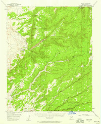
1955 Map of Nazlini
USGS Topo · Published 1959About this map
Nazlini and the surrounding high desert of the Navajo Indian Reservation appear here in a mid-century topographic study. The landscape is defined by its complex drainage network, where Nazlini Creek and Tsegi-ot-Sosi Creek carve through the prominent elevations of Rock Mesa. To the northeast, the map touches upon the boundaries of Canyon de Chelly National Mon, while the southern reaches are marked by seasonal watercourses like Black Soil Wash and Willow Wash.
Find a feature on this map
26 named features on this map. Tap any name to fly to it.
Don’t see what you’re looking for? This feature index may not catch every label — zoom into the map to look around manually.
Map Details
Editions of this 1955 Nazlini Map
2 editions found
Other maps of this area

1886 · Fort Defiance
USGS Topo · 1:250,000

1892 · Fort Defiance
USGS Topo · 1:250,000

1892 · Canyon De Chelly
USGS Topo · 1:250,000

1954 · Shiprock
USGS Topo · 1:250,000

1954 · Gallup
USGS Topo · 1:250,000

1955 · Zith-Tusayan Butte 3 NW
USGS Topo · 1:24,000

1955 · Zith-Tusayan Butte 2 SE
USGS Topo · 1:24,000

1955 · Zith-Tusayan Butte 4 NW
USGS Topo · 1:24,000

1955 · Zith-Tusayan Butte 2 SW
USGS Topo · 1:24,000

1955 · Zith-Tusayan Butte 3 NE
USGS Topo · 1:24,000
Featured Places
- Chinle Agency, AZ
- Fort Defiance Agency
- Nazlini, Chinle Agency
- Wood Springs, Chinle Agency
- Kinlichee, Fort Defiance Agency