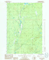
1985 Map of Ned Lake SE
USGS Topo · Published 1986About this map
The Deer River and its numerous tributaries dominate this mid-1980s landscape in Iron County, illustrating the intricate hydrology of the Copper Country State Forest. The map documents a rugged timber and mining region where industrial history is marked by a prominent Old RR Grade winding through the terrain near Diana Pond. Resource extraction and recreation converge at the Gravel Pit and Campground near the shores of Deer Lake.
Find a feature on this map
32 named features on this map. Tap any name to fly to it.
Don’t see what you’re looking for? This feature index may not catch every label — zoom into the map to look around manually.
Map Details
Editions of this 1985 Ned Lake SE Map
This is the sole edition of this map. No revisions or reprints were ever made.
Other maps of this area

1895 · Ned Lake
USGS Topo · 1:62,500

1899 · Sagola
USGS Topo · 1:62,500

1899 · Witbeck
USGS Topo · 1:62,500

1899 · Crystal Falls
USGS Topo · 1:62,500

1945 · Kelso Junction
USGS Topo · 1:24,000

1945 · Amasa
USGS Topo · 1:24,000

1947 · Kiernan
USGS Topo · 1:24,000
1947 · Amasa
USGS Topo · 1:24,000

1947 · Kelso Junction
USGS Topo · 1:24,000

1955 · Ned Lake
USGS Topo · 1:62,500