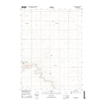
2015 Map of Needle Rock
USGS Topo · Published 2015About this map
Needle Rock and its surrounding geological formations anchor this Goshen County landscape, where the high plains break into distinct draws and canyons. The topography is defined by significant landmarks like Steamboat Rock and Sugar Bowl Rock, which serve as natural waypoints in an otherwise sparse western terrain. Water drainage follows a network of intermittent creeks including Lone Tree Creek and YBO Creek, carving out seasonal paths such as Needle Draw and Jackson Canyon.
Find a feature on this map
22 named features on this map. Tap any name to fly to it.
Don’t see what you’re looking for? This feature index may not catch every label — zoom into the map to look around manually.
Map Details
Editions of this 2015 Needle Rock Map
This is the sole edition of this map. No revisions or reprints were ever made.
Other maps of this area

1899 · Goshen Hole
USGS Topo · 1:125,000

1954 · Cheyenne
USGS Topo · 1:250,000

1958 · Cheyenne
USGS Topo · 1:250,000

1960 · Veteran
USGS Topo · 1:24,000

1960 · Diamond Flat
USGS Topo · 1:24,000

1960 · Hawk Springs
USGS Topo · 1:24,000

1960 · Needle Rock
USGS Topo · 1:24,000

1960 · Kessler Gap
USGS Topo · 1:24,000
1960 · Yoder
USGS Topo · 1:24,000

1963 · Y B O Canyon
USGS Topo · 1:24,000